1783 composite map of the Americas
Japanese pictorial map of North America from 1924
Japanese pictorial map of North America from 1924
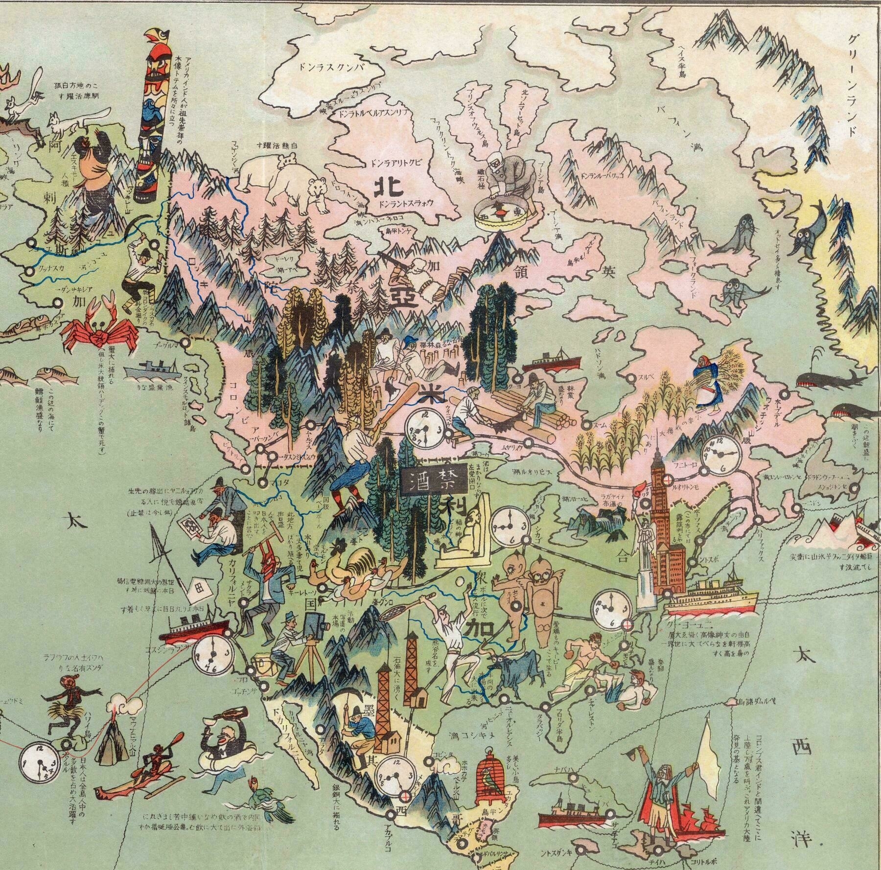
‘There are too many words here to translate. About half of them are just transliterations of corresponding place names.
The others are descriptions of nearby illustrations, such as: In Caribbean see, “Columbus landed here, which he believed to be India. This was the beginning of discovery of American Continent.” In Atlantic Ocean, “Titanic sank because of an iceberg.” Crab and fish in Pacific Ocean says “there are plenty of them.”
Some of the descriptions are prejudices of Japanese people at that time, and I think are reflected by propaganda of Japanese Empire, although somewhat interesting and funny.
Here’s a couple more (my Japanese is only intermediate, so some subtleties might be off):
It marks Portsmouth, New Hampshire (ポーツマス) and says “Russo-Japanese negotiations happened in this city.”
Off of Honolulu it says “Japanese people splendidly make up large numbers of people on all islands.”
Off the west coast of Mexico it says “They are able to excavate lots of copper and silver.”
Over North Dakota the black bar with the two kanji says “Prohibition (of alcohol).”
A more natural translation of message near Hawai’i would read, “Japanese people live on all the Hawaiian islands, making up a large proportion of the population.”
The 大活躍 doesn’t mean “splendid” but rather “very active.”’
1698 Friar Hennepin map of North America
1698 Friar Hennepin map of North America
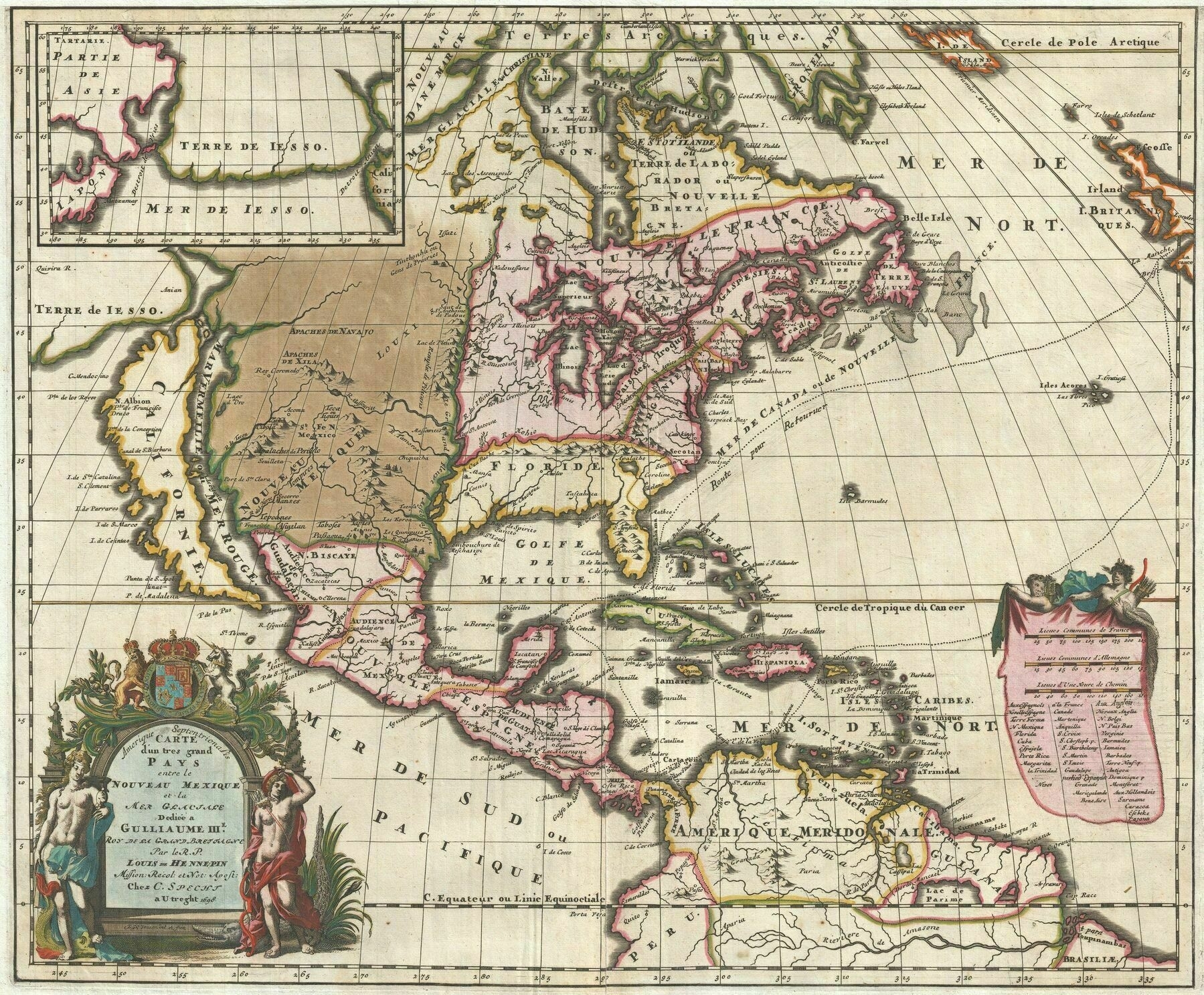
“A map that fundamentally impacted the cartographic history of America”
North American Remoteness
North American Remoteness
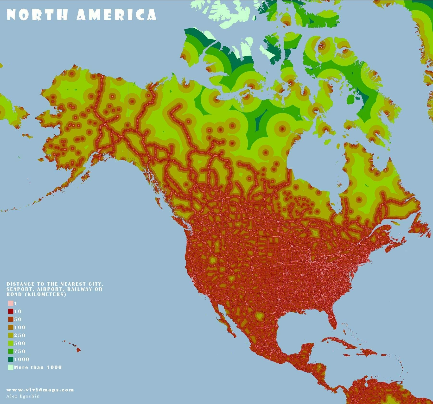
‘You can see the bottleneck in the Canadian network near Thunder Bay, Ontario, where there’s only two east-west road links, the Trans-Canada Highway and the Canadian National Railway line a bit north of it. Other than those two, you need to go into the US or take a plane to get from one side of Canada to the other’
The difference between highest and lowest temperature in the U.S. and Canada
The difference between highest and lowest temperature in the U.S. and Canada
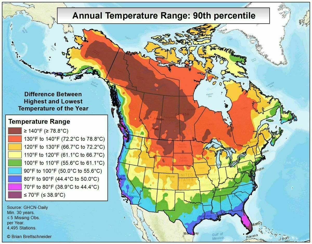
‘That’s a large difference. In most of Europe, the differences are probably smaller than 50 °C, maybe even less than 40 °C.
In Prague, the highest temperature in a single year is usually around 35 °C and lowest is around -10 °C’
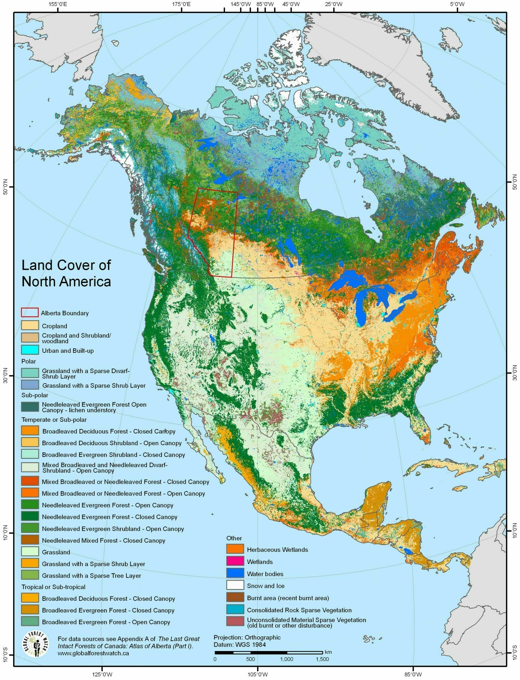
Land cover of North America
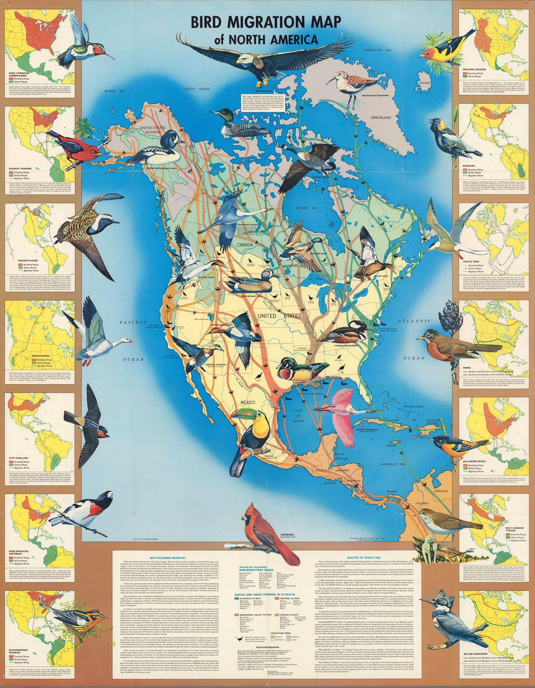
Bird Migration Map of North America (1960)
Linguistic Stocks of American Indians North of Mexico (1881)
Linguistic Stocks of American Indians North of Mexico (1881) - by J.W. Powell
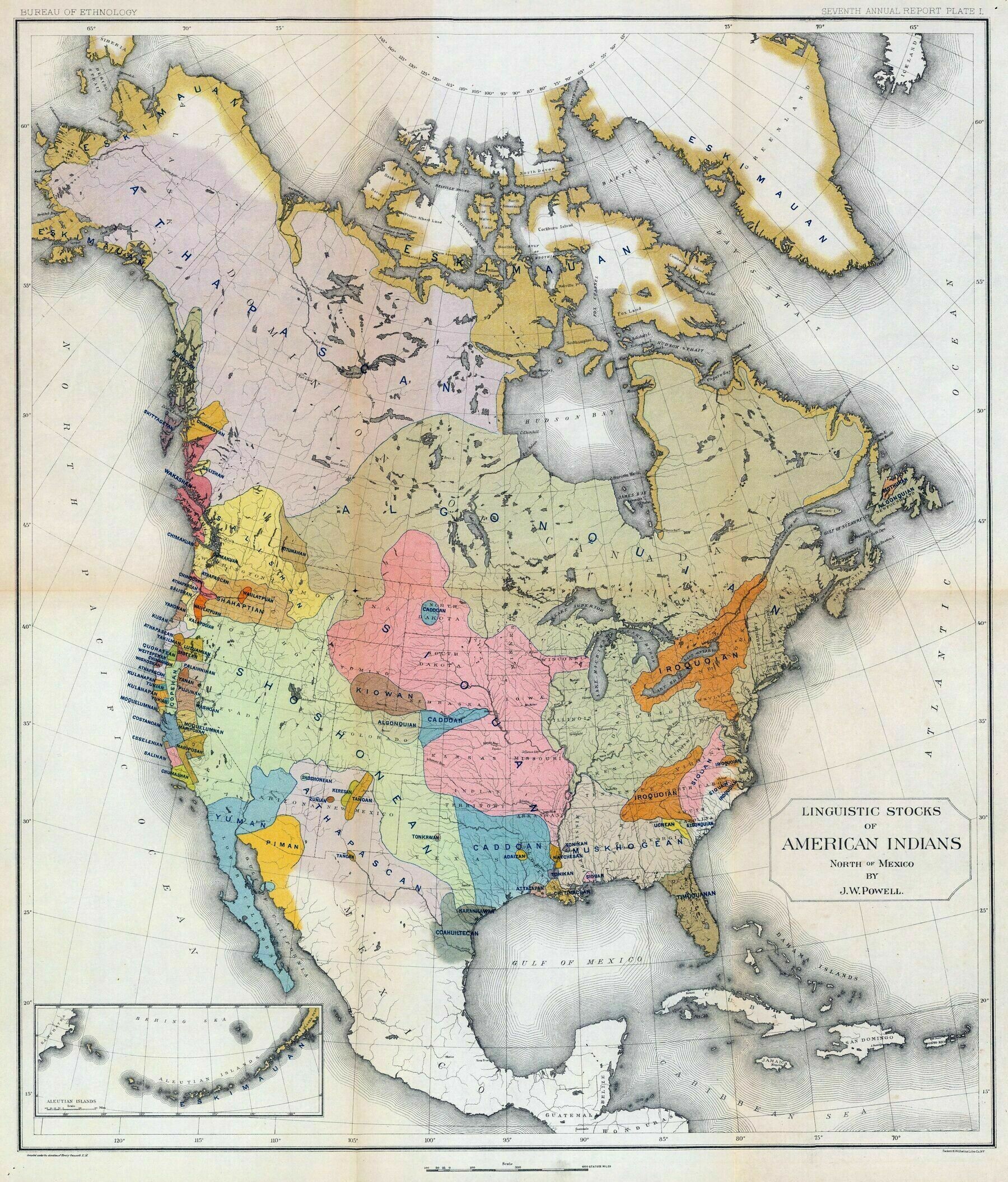
‘So interesting that the Siouan languages form a general outline of the Louisiana Purchase’–quackchewy
Pictorial map of North America (1930) - by Margaret Whiting Spilhaus
Pictorial map of North America (1930) - by Margaret Whiting Spilhaus
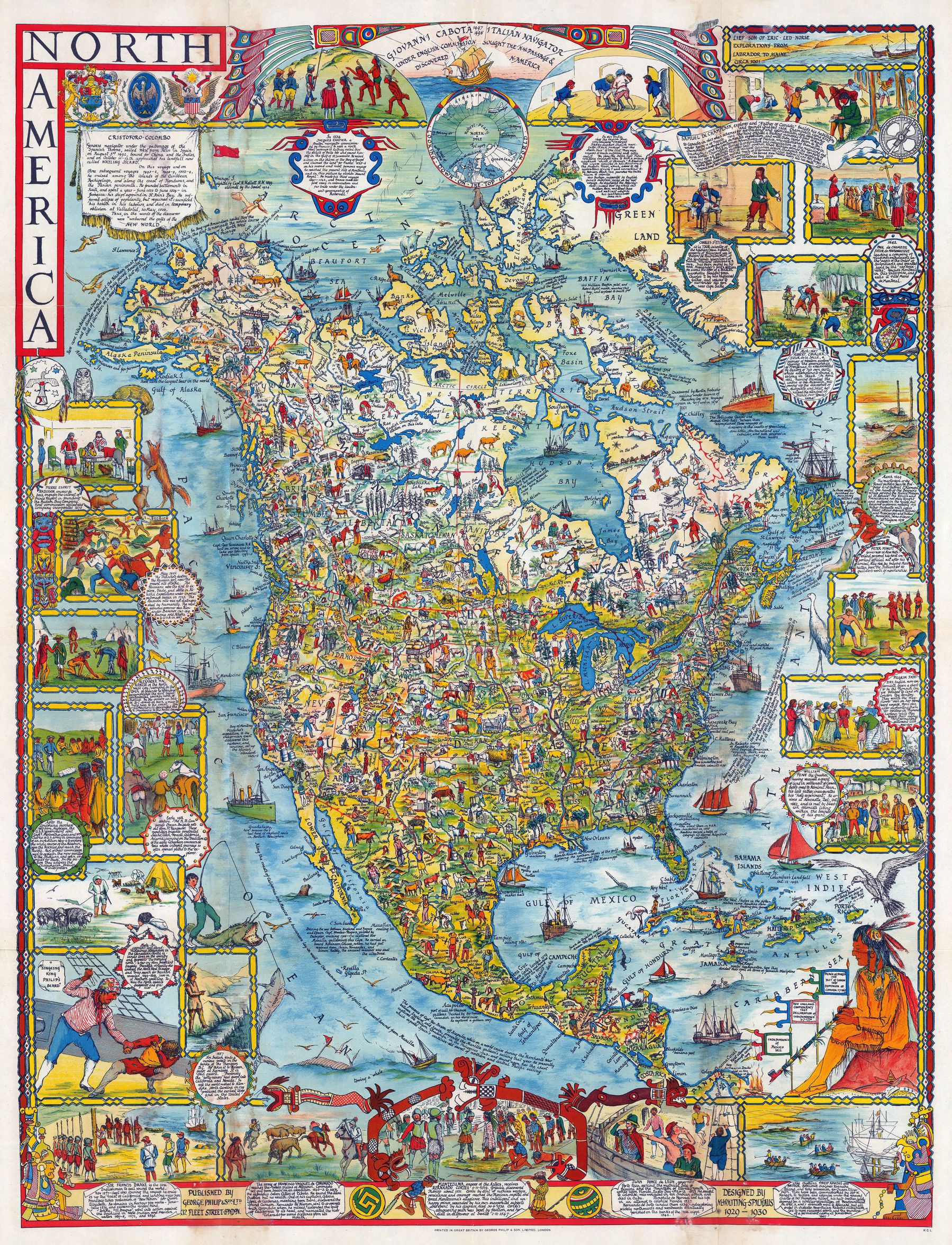
‘See?! What did I say? The world was crazy for pictorial maps in the 30s and 40s’–corruptrevolutionary
Colton's 1865 map of North America
Colton’s 1865 map of North America
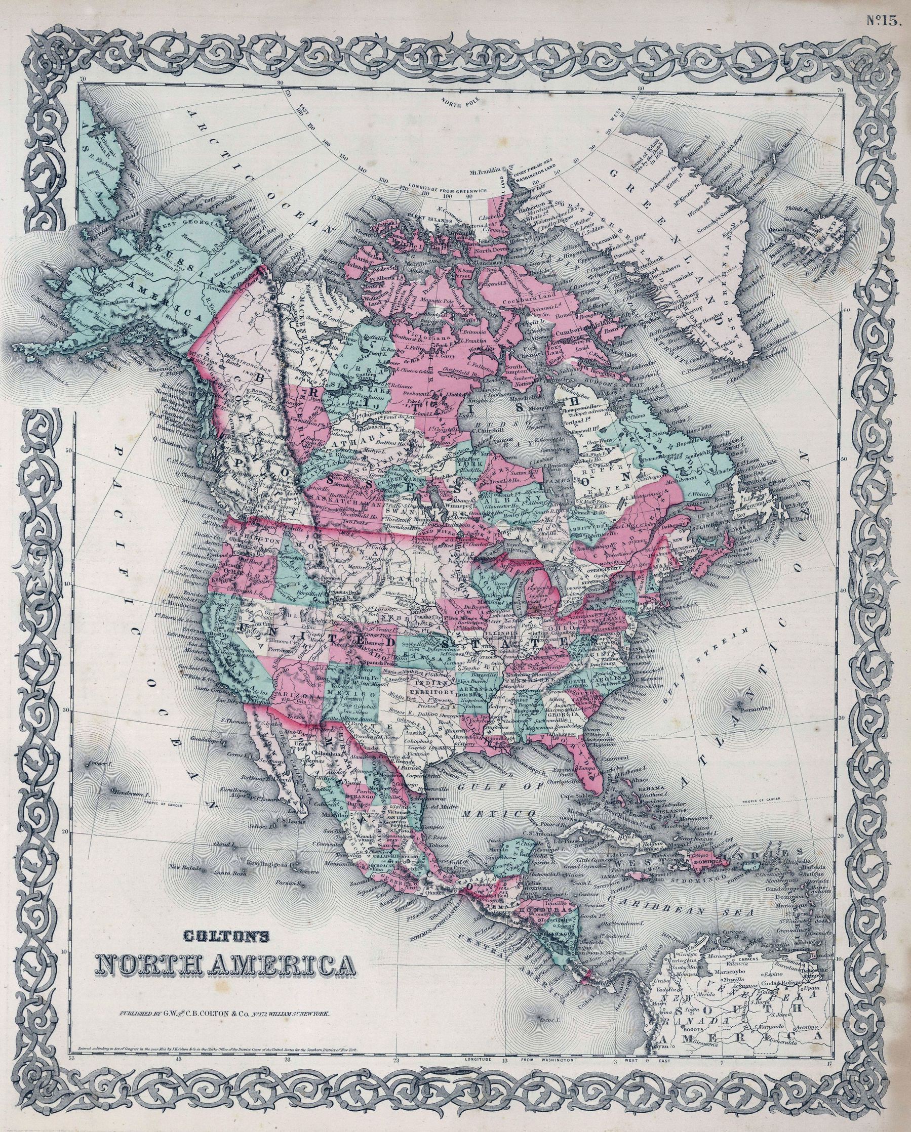
‘Finally, a United Dakota. A true world powerhouse’–Thekman26
The River Systems of America (1856)
The River Systems of America (1856)
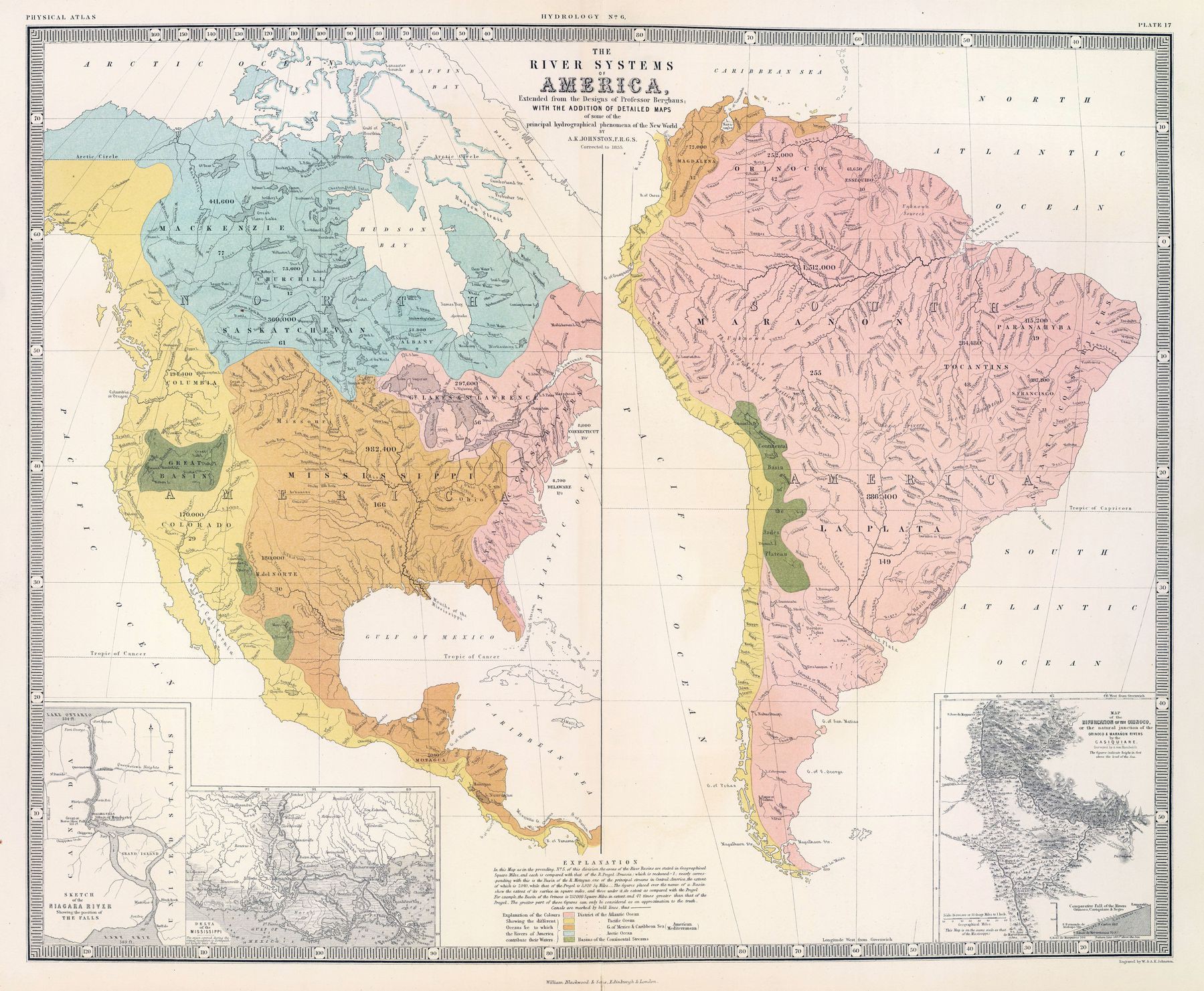
‘Fun fact. Technically a fish could swim through the USA from the Gulf of Mexico to the Pacific Ocean. A creek in Wyoming splits in two and eventually reaches both the Mississippi and the Columbia Rivers’–desperadow
Ethnicities in America in 1880 (published 1892)
Forest Cover of the Americas
Forest Cover of the Americas
‘The Andes create a rain shadow over Argentina, leaving Patagonia as essentially a cold desert’–ilovesfootball
Coldest season of the year based on data from over 11,000 stations in U.S. and Canada
Coldest season of the year based on data from over 11,000 stations in U.S. and Canada
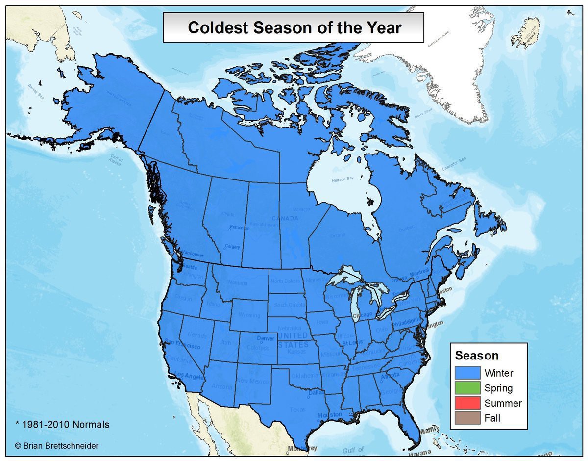
“Wow this really gets you thinking…
About building a heavily insulated bunker 40 ft underground stocked with a metric boatload of Fanta, guns, and cheezits waiting for the inevitable Thermal Apocalypse?
I’m on the same page, brother…”
Geologic map of North America. Ages of the bedrock - red (oldest) to blue, green, yellow (newest)
Geologic map of North America. Ages of the bedrock - red (oldest) to blue, green, yellow (newest)
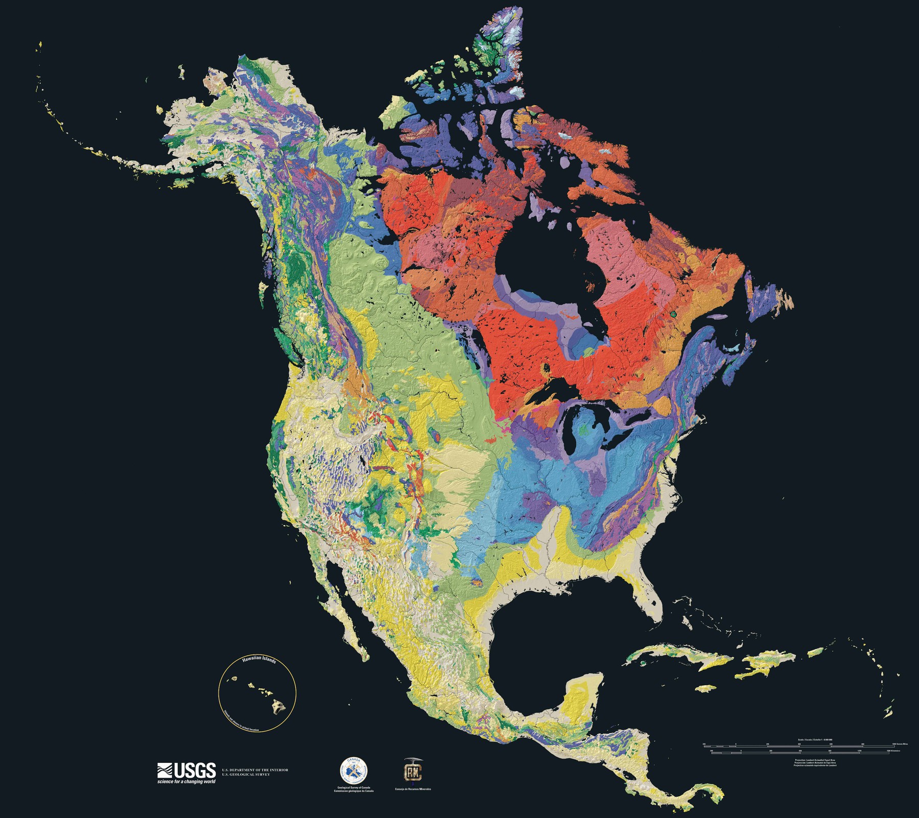
“The oldest rock there is some of the oldest on the entire planet, going back billions of years. Billions. You can go there and look at something that was fully-formed when life on Earth consisted of ocean microbes”–KubrickIsMyCopilot
1587 map of the Americas, Pacific - by Abraham Ortelius
1587 map of the Americas, Pacific - by Abraham Ortelius
[5783 × 4190]
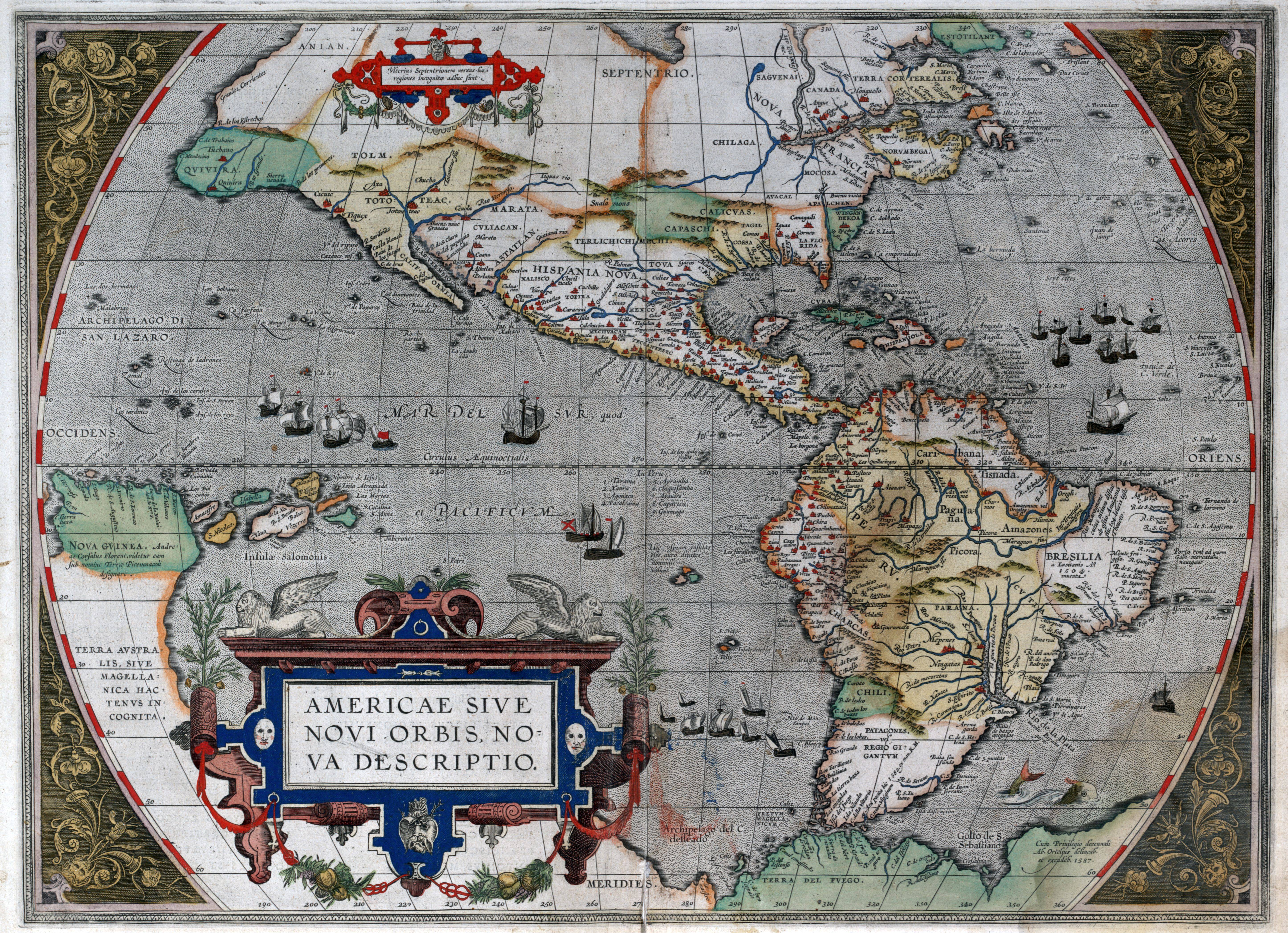
“Very nice map.
“The passage at the bottom of South America is in fact the Strait of Magellan, (Latin: fretum magellanicum). South of it is Terra del Fuego (Spanish: Land of Fire). Cape Horn was not discovered until 1616 proving that Terra del Fuego was not the northern part of what would later be named Antarctica”–doitstuart
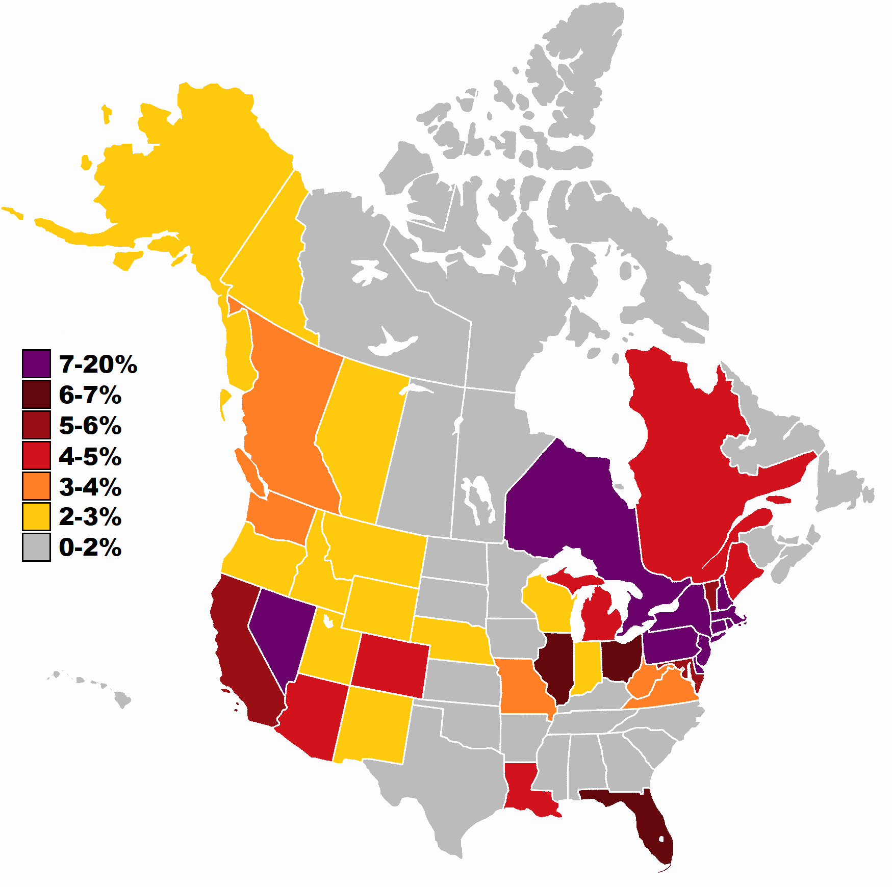
Irish ancestry in the USA and Canada
Irish ancestry in the USA and Canada
“Okies lots of people moved out there back when it was opened to expansion, talked about in Steinbeck grapes of wrath”–VarysIsAMermaid69
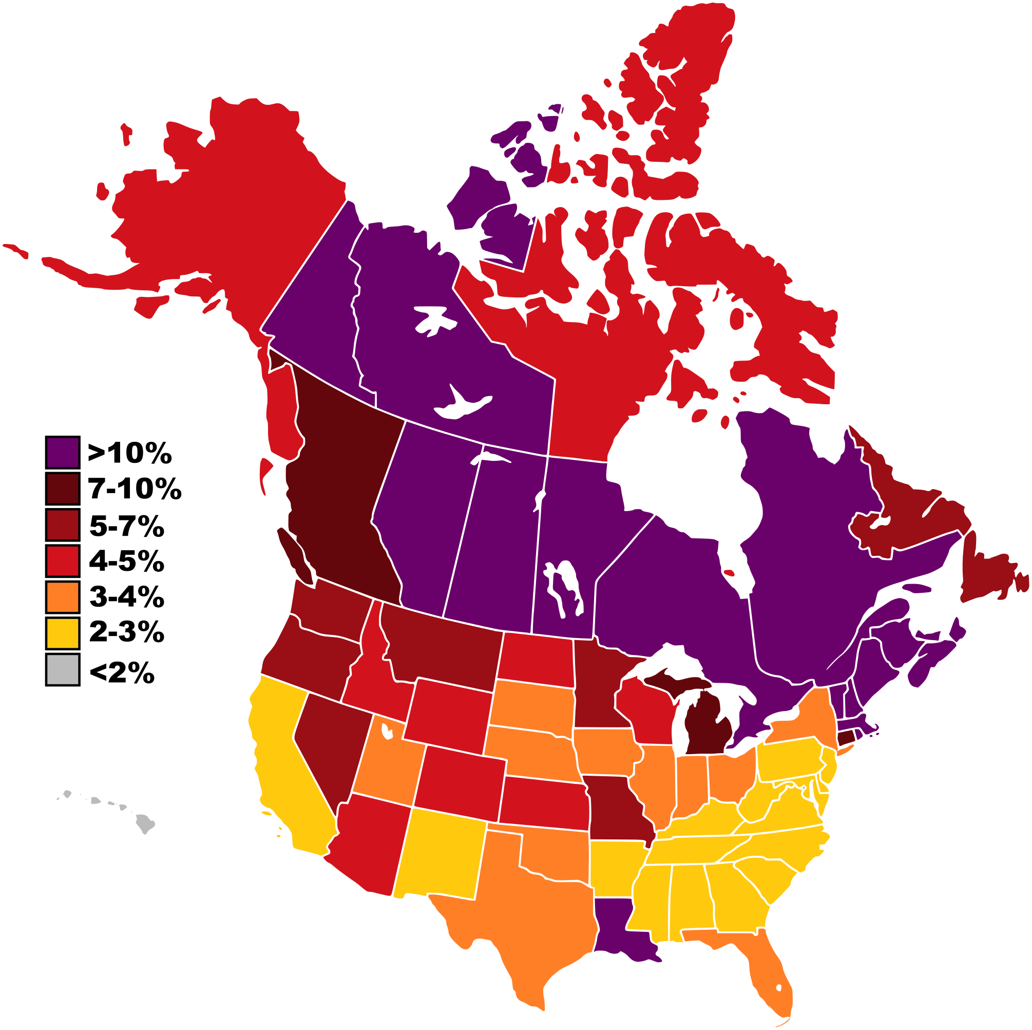
Italian ancestry in the USA and Canada
Italian ancestry in the USA and Canada
“LOL, Nevada.
Gee, I wonder where that came from”–KubrickIsMyCopilot
French ancestry in the United States (2000 census) and Canada (2016 census)
French ancestry in the United States (2000 census) and Canada (2016 census)
“There needs to be a different scale for Canada”–RawPinkFlesh
Largest ethnicities of Canada and USA
Largest ethnicities of Canada and USA
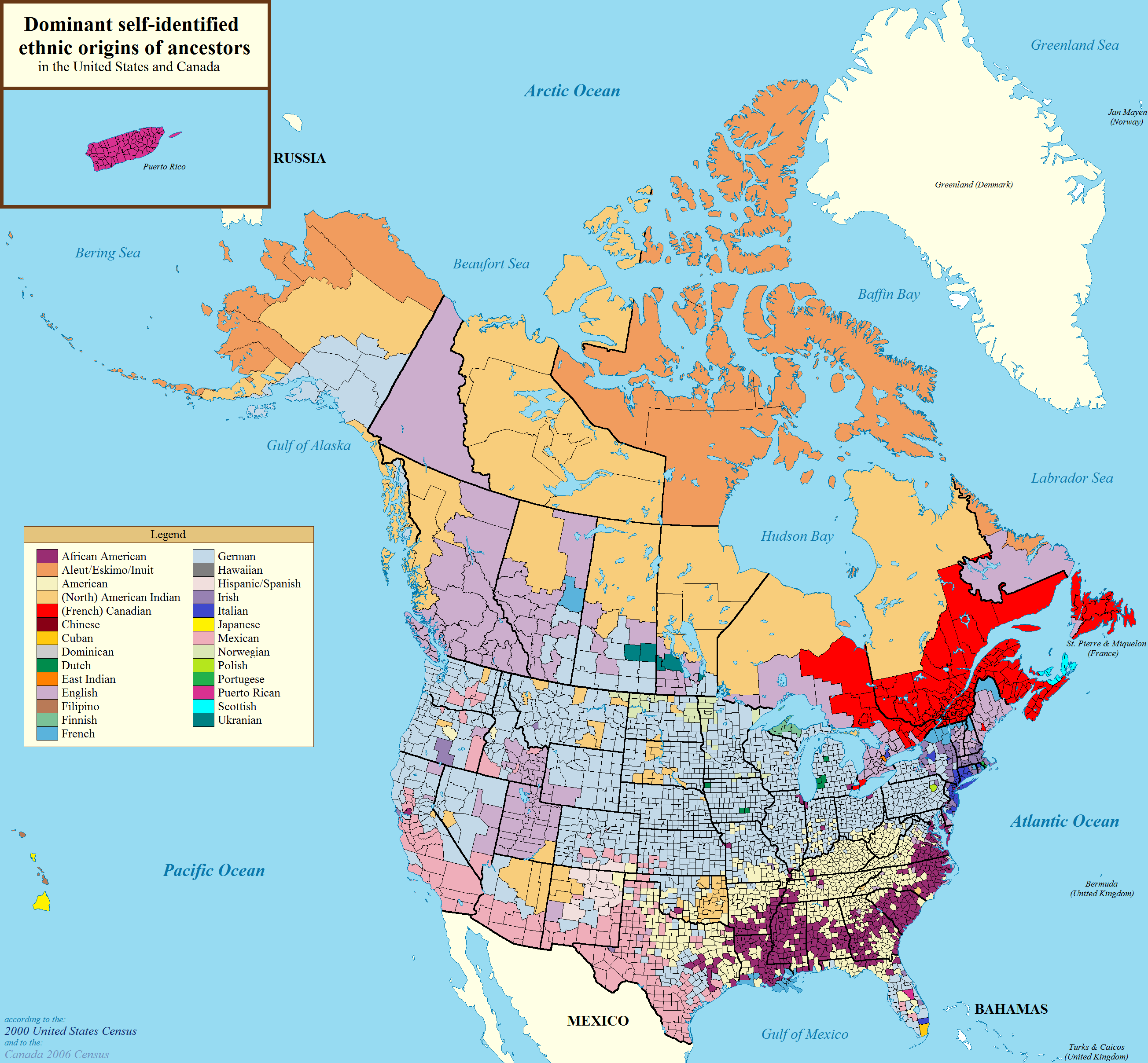
“British Americans, namely those of English descent but also Scottish and Scots-Irish Americans, are severely under reported in these surveys. Those ethnic Americans in the Southeast are mostly the descendants of old Anglo and Scots-Irish settlers from the colonial era and I’d wager half those “Germans” and “Irish” Americans have substantial Anglo heritage”–Disillusioned_Brit
Spanish Activity in North America
Spanish Activity in North America
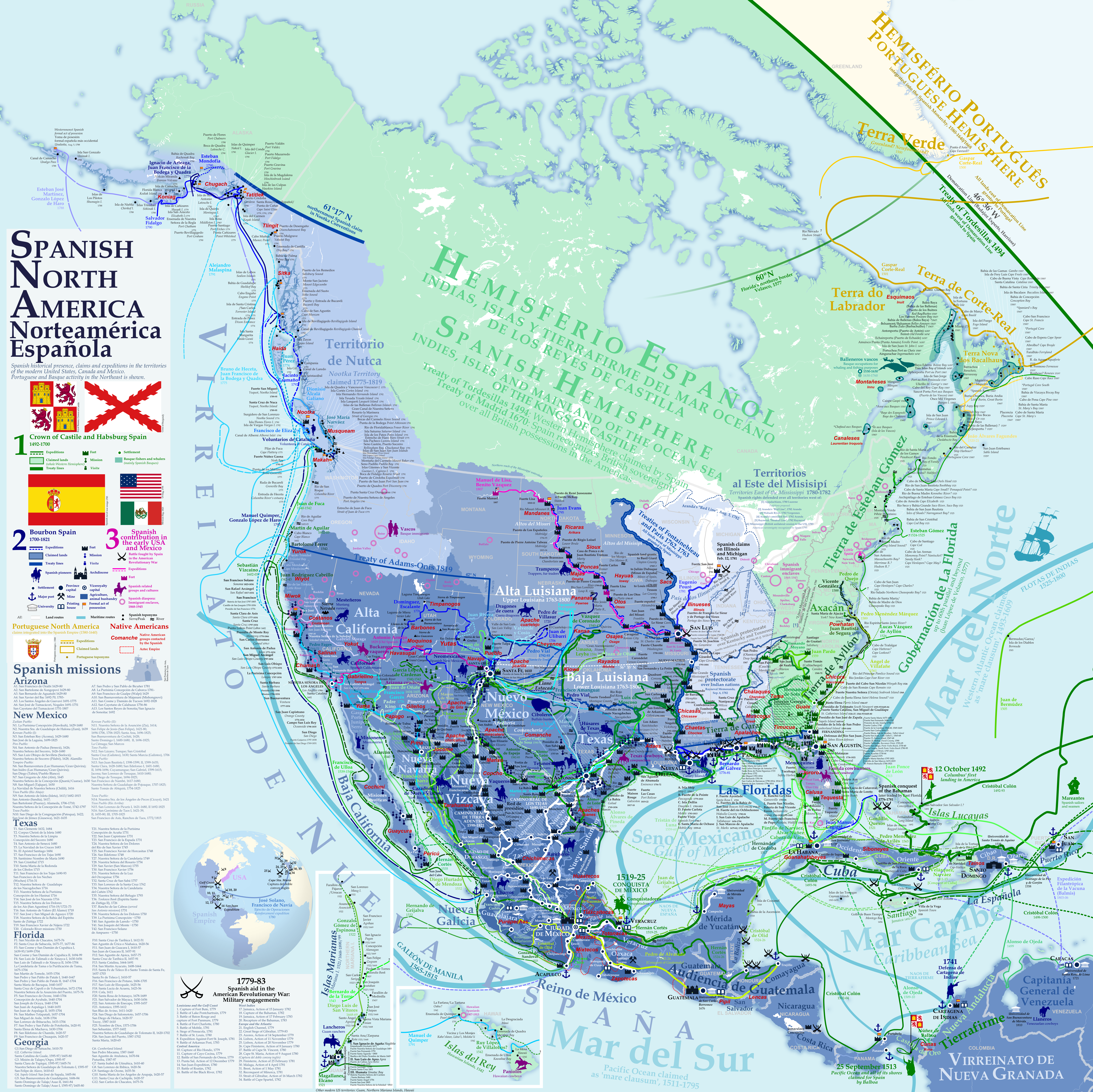
“absolutely amazing map, Spanish NA is tragically overlooked in a lot of hstorical contexts, very fascinating time period, for example oneof the only succesful native american revolts occurred in Spanish NA, the Pueblo Revolt”–VarysIsAMermaid69
Dialects of the United States and Canada
Dialects of the United States and Canada
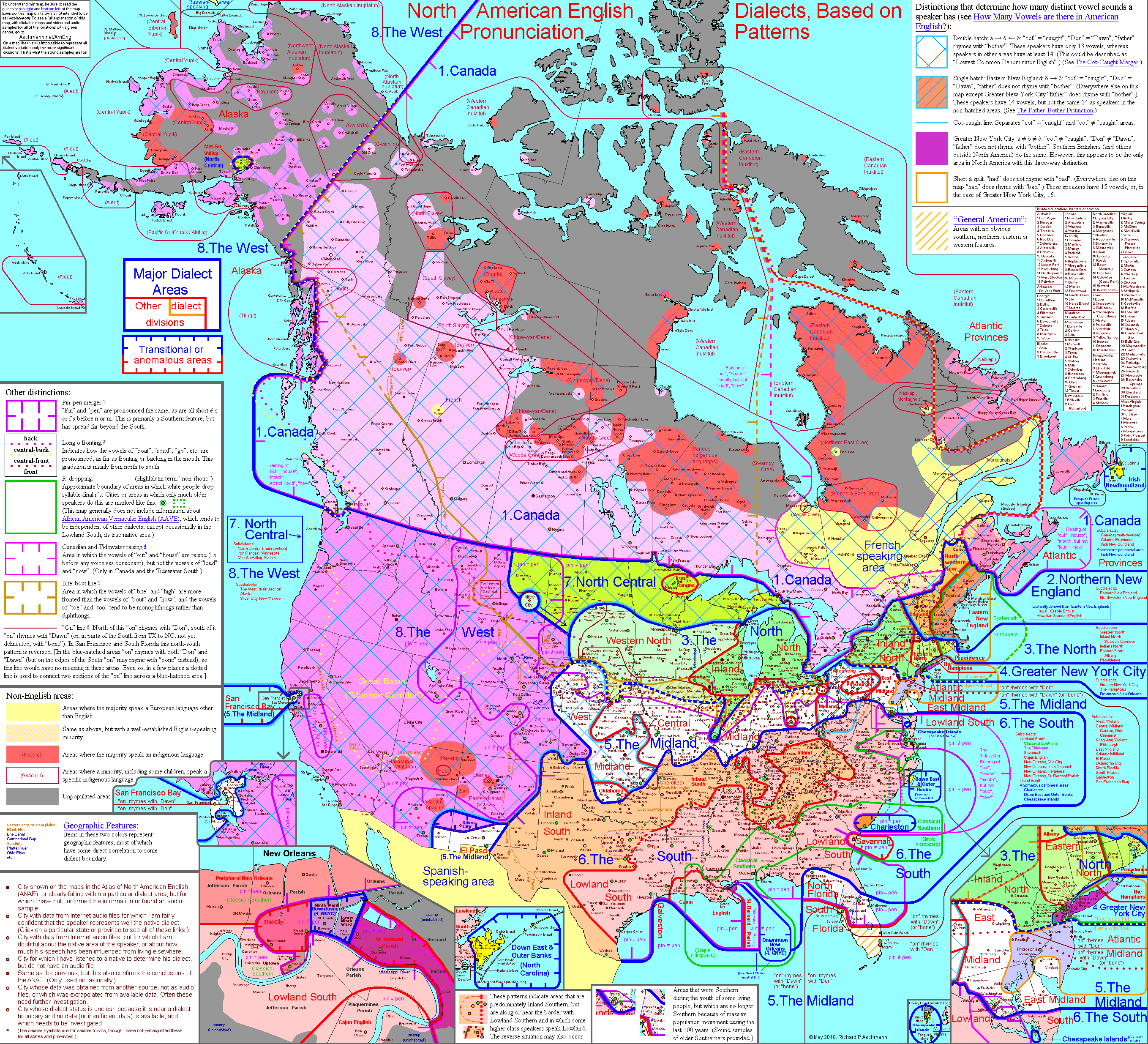
It’s designed to be searchable and zoomable - aschmann.net/AmEng/
Shaded relief hand-painted map of America (originally created in 1965) blended with NASA imagery by John Nelson
Shaded relief hand-painted map of America (originally created in 1965) blended with NASA imagery by John Nelson
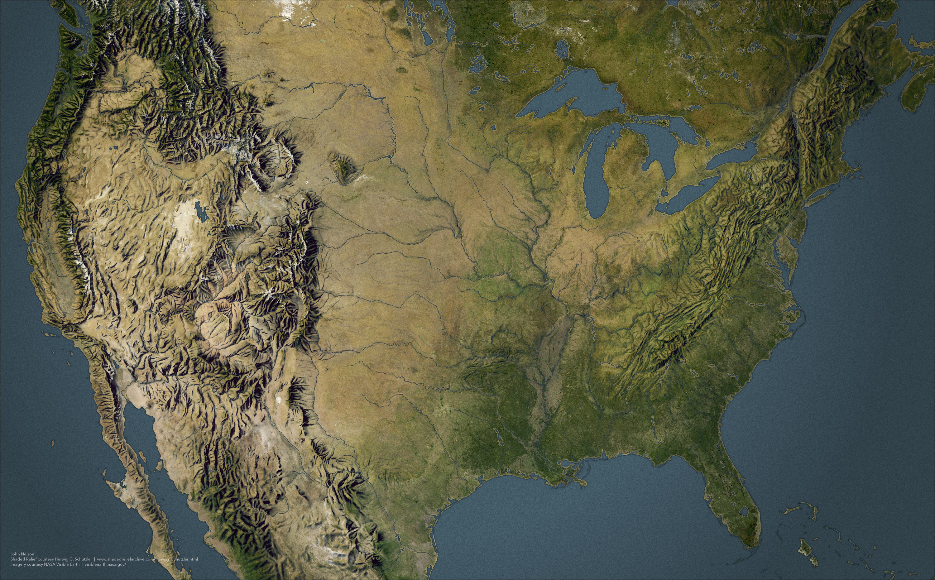
“I live how the Hudson just slices new England off so cleanly”–nfestans
Mapa de Relieve de México
Exaggerated relief map of Mexico
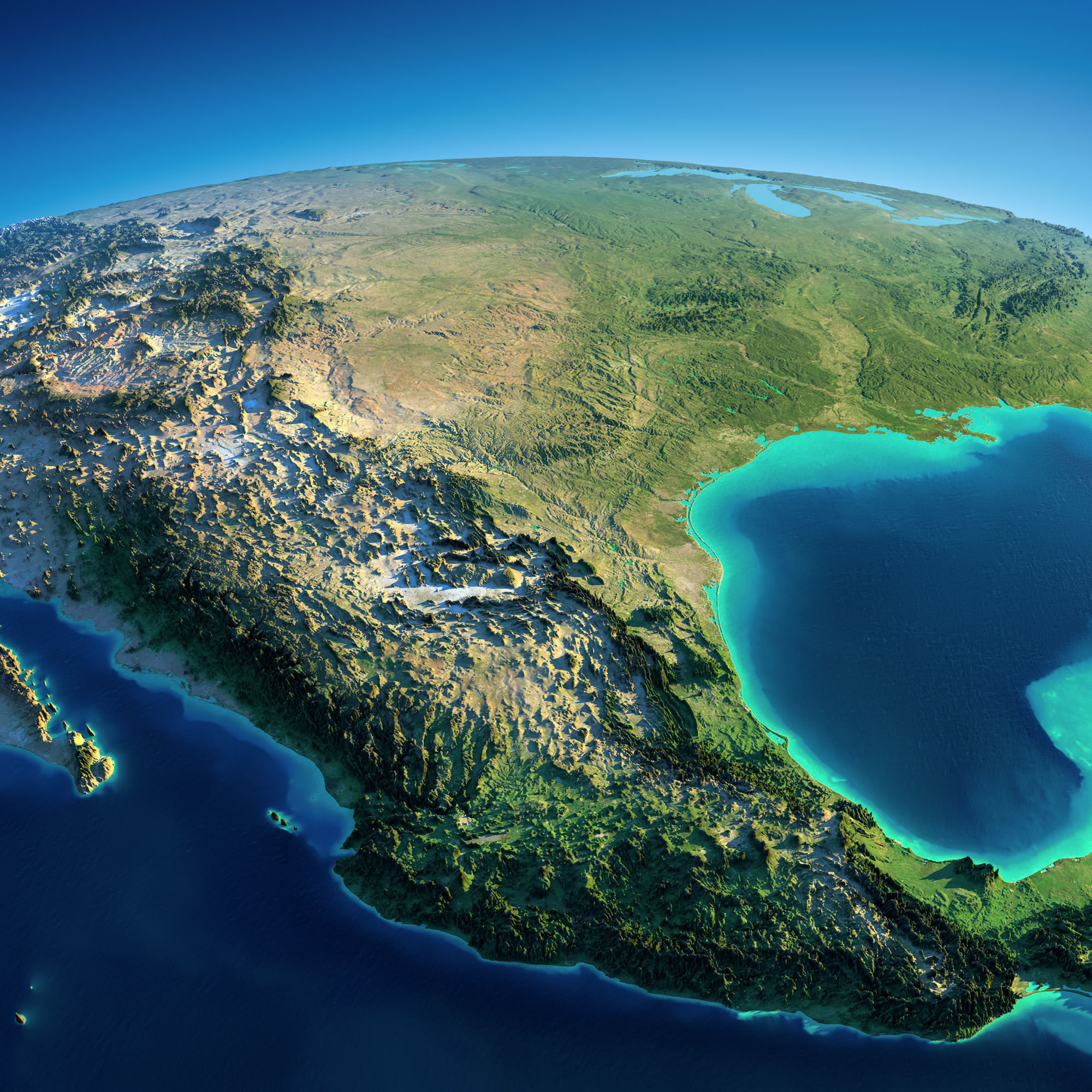
“Según yo, la CDMX y Monterrey estarian aqui”–Kuramo